 «
«  D u t c h R h u d y »
Reference Maps
Welcome to the Roaring Falls™ Series Reference Maps my Friend, and Thank You for Visiting!
Our Reference Maps section is divided into separate pages for State, County, and City Maps.
The complete listing can be found on the Expanded Index in our Visitors Center.
Roaring Falls is a huge city within the State of New Clemons, which spans nearly twenty decades of continuous growth. The History of Roaring Falls begins with the first exploration team to chart the mid-west, and proceeds through the first trapper and pioneers, to the first settlers, and continues to the present day.
Each novel in the series is written for a specific era, and about a particular event or series of events which occurred during their respective time frames. Overall, the series is about the growth of the worlds largest detective agency, Rumbleigh Investigations; however, we cannot overlook the historical aspects of how and where the agency got started, nor the families involved in the growth of the city or its businesses.
These casual drawings and plat maps will assist our readers in visualizing the many scenes, and their precise locations more fully than mere words on a page. As they say, one picture is worth a thousand words!
City of Roaring Falls, Yarnell County, New Clemons
Welcome to the Roaring Falls City Hall.
Roaring Falls is nestled in a quiet transitional region, where the parched Prairie gives up its heat to the refreshingly cool, lush forests teeming with abundant wildlife. The terrain then ascends into the lightly humid foothills of Bluff Mountain, which stretches west toward the Rockies.
With lace-like delicacy, high atop Trident Tines Plateau; cool mountain streams meander their way between the Regal Quartet's tall peaks forming Butterfly Lakes. From these magnificent lakes, three towering waterfalls gracefully dance over a golden backdrop as they pour into crystal clear Emerald Glass Lake.
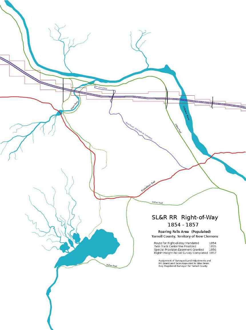
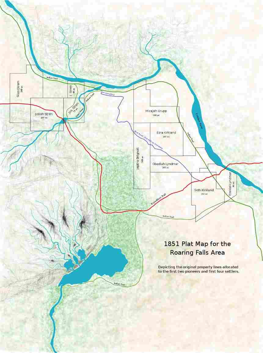
Our modern community of Roaring Falls, boasts of a heritage that began more than 175 years ago. Trappers and early pioneers following a distinct trail, forged by the exploration team who mapped the central mid-west, put down roots in the newly acquired Indian territory. Wagon trains following this precise course, soon brought the first settlers into the Roaring Falls Area.
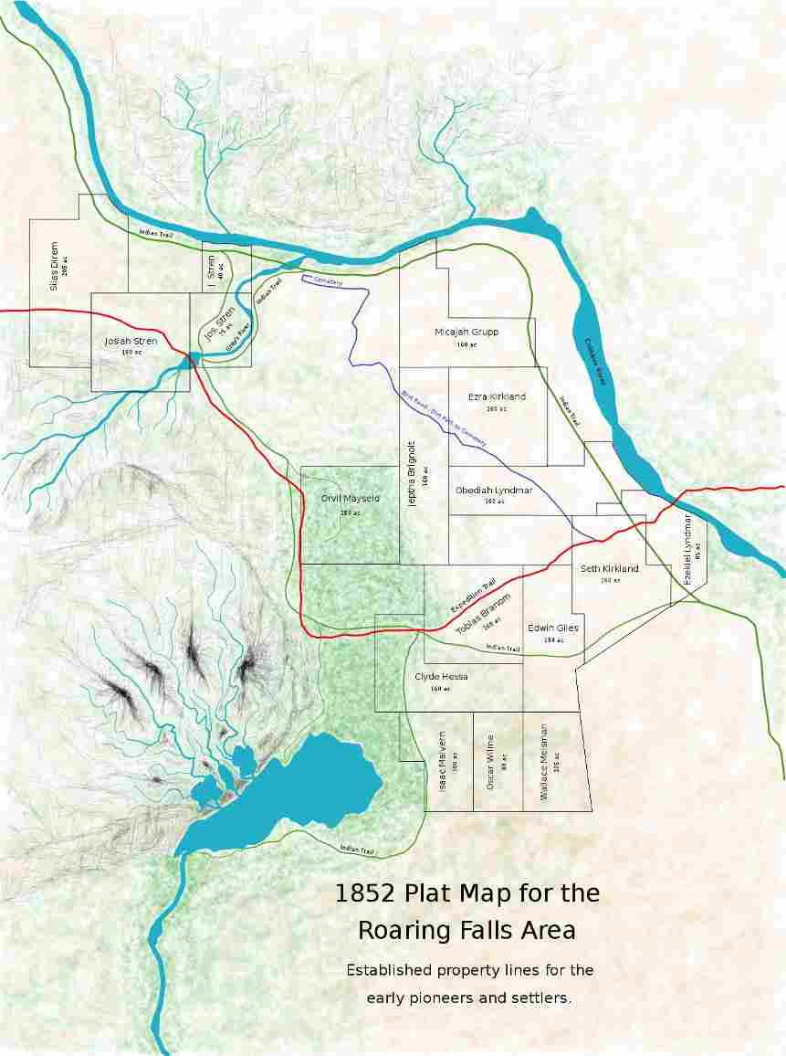
When the region was surveyed and opened for colonization, more families joined the community, and business developments flourished along the expedition trail. The Kirkland Stage Lines are responsible for imparting its name to this route, which later became the first paved road in Roaring Falls.
This thriving city clings to its earlier agricultural background, while giving the appearance as a recent development. Several century-old homes blend unnoticed with their contemporary new neighbors. Well-preserved early historical structures, including two stone Churches constructed in the 1850s, and Stren's Mill completed in 1866, are a reminder of Roaring Falls elegant past.
The three majestic waterfalls, for which the city was named; its pristine lakes and lush forests, draw tourists from all corners of the globe. Shoppers flock to the massive new mall at Gray's Crossing, and enjoy visiting the many quaint shops and stores in the Old City Area, boasting of a gentle, simpler lifestyle, from days of yore.
The sprawling municipality of Roaring Falls incorporates 34.7 square miles. From its historical Old City Area on the Coteaux River, it expands through vast level acres of prime farming and grazing land, before transitioning through a beautiful verdure landscape of heavily wooded, low rolling hills. Traveling southwest on Fawn Valley Parkway, we find the land slowly metamorphosing into a lush, dense forest, where it climaxes at the foot of picturesque Trident Tines Plateau.
1851 First Settlers Plat Map Return To Top
1852 Second Settlers Plat Map Return To Top
1854-1857 SL&R Railroad Right-of-Way Map Return To Top